|
MapCatalog | Order | Support | SiteIndex | Contact | Home | ||||||||||
|
|
|
|
|
|
|
|||||||||||
| MH Maps | Tech Spec | Download | License | Showcase | Reviews | |||||||||||
|
MapCatalog | Order | Support | SiteIndex | Contact | Home | ||||||||||
|
|
|
|
|
|
|
|||||||||||
| MH Maps | Tech Spec | Download | License | Showcase | Reviews | |||||||||||

Introduction to MHM
Spécification Technique
Technical Specification
MOUNTAIN HIGH MAPS is published as a complete world maps package, individual maps, and by continental collections - all for immediate download. It is available for use on all computers running Macintosh, Windows and Unix environments.
The Mountain High Maps DVD map collection contains:
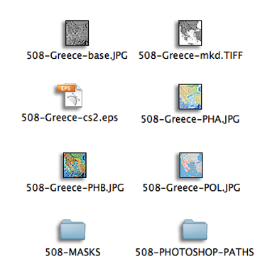
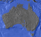
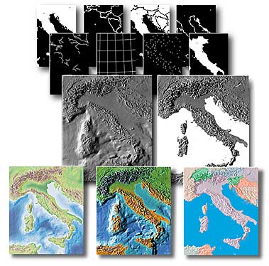
1. 78 high-resolution (300ppi), relief maps in four variations of colorization, plus vector paths and a variety of bitmap masks. The high resolution maps are all identified by the suffix ".JPG" or ".TIFF" as in "5.08 Greece-base.JPG" on Macintosh or "508GRE3B.JPG" in Windows The relief maps feature ocean floor relief as well as land relief. These are identified as follows:
Number: each map and all masks relating to that map are prefixed by a number, as in "508-Greece"
Colorized maps, physical "A" (land and ocean floor relief colorized according to elevation): "PHA.JPG" as in "508-Greece-PHA.JPG"
Colorized maps, physical "B" (land and ocean floor relief colorized according to vegetation): "PHB.JPG" as in "508-Greece-PHB.JPG"
Colorized maps, political (land relief colorized according to international boundaries): "POL.JPG" as in "508-Greece-POL.JPG"
Base relief maps (land and ocean floor relief in grayscale): "base.JPG" as in "508-Greece-base.JPG"
Masked relief maps (land relief in grayscale, with white ocean areas): "mkd.TIFF" as in "508-Greece-mkd.TIFF"
2. 39 high-resolution (300ppi), globe views with corresponding ocean/land bitmap masks, identified as follows:
Grayscale globes (land relief with oceans white, TIFF format): "mkd.TIFF" as in "705-0°-180°-msk.TIFF"
Colorized globes (15 globes with fully colorized land relief and blue oceans, JPEG format): "COL.JPG" as in "704-0°-135°E-COL.JPG"
3. Corresponding outline versions of the maps (not globe views) in Adobe Illustrator EPS format. These are identified by the suffix ".eps". The Illustrator files provide fully-editable outlines of each map, with each country placed on a separate layer for easy location and editing. Additional layers include rivers, major cities, graticules (lines of latitude and longitude), and scales. All long paths are split into smaller chunks - although Illustrator allows documents to have paths with more than 1,000 points, it will not print any fills applied to those paths, so areas with colored fills have been "tiled" to assist in printing. The Illustrator files also include a layer onto which the corresponding relief maps can be placed.
4. View the online Map Catalog for useful technical information about the maps.
The Illustrator file formats provide fully-editable outlines of each map, with each country placed on a separate layer for easy location and editing. Additional layers include rivers, major cities, physical features, graticules (lines of latitude and longitude), and scales. The Illustrator files can be placed directly into any word-processing or page layout application which accepts the EPS file format.
The TIFF images are best used with image-editing applications such as Adobe Photoshop but they can also be used within page layout and drawing applications, where color can be applied directly.
Using the maps
The Mountain High Maps TIFF and JPEG formats can be used either on their own, or with the Illustrator files.
Download the free Map Tutorial written with detailed step by step Photoshop instructions on how to build a promotional artwork image using MOUNTAIN HIGH MAPS including some stock imagery also provided.
Files sizes
The map and globe images have an uncompressed file size of approximately 10 Gbytes. The grayscale high resolution maps range from 3 Mbytes to as high as 17 Mbytes uncompressed, averaging around 5 Mb grayscale and colorized maps between 10 to 50 Mb in RGB. Individual map images differ in size, averaging around 2,000 to 2,500 pixels in height and width; the largest world map is sized at 5,500 x 3,500 pixels. Issues relating to the quality and size of images are covered in Frequently Asked Questions page.
Map scales
Horizontal scales range from 1:250,000 up to 1:45,000,000, giving on the ground pixel resolution varying from 200 metres to 12 km. Typical resolution for European countries is 500 metres, for US 1,000 metres, continental views range from 3 km to 6 km. Vertical scales range from 1:50,000 to 1:1,000,000, with contour intervals varying from 50 to 1,000 feet. To emphasize relief, the elevation scales have been exaggerated 5 to 30 times. The maps use many projection systems including Mercator, Gall, Lambert's equal-area, conformal conic, simple conic and zenithal.
Political accuracy
Mountain High Maps Version 4.0 has been revised for all known and ratified political border decisions - updates since that date can be downloaded on request by registered users from this web site. The regulating authorities whose advice has been sought in the preparation of the Mountain High Maps material are the Office of the Geographer at the US Department of State, Washington DC and the International Boundaries Research Unit (IBRU) at the University of Durham in England. A list of unresolved border disputes is documented in a disc based documentation tool, and where appropriate disputes have been clearly identified in Illustrator files as purple border lines.
Continental Editions Version 4.0
Continental Editions divides the Mountain High Maps V.4.0 collection into six competitively priced collections for designer's who only need a few maps in one continental region of the world. Check our Continental Editions for more details of the Continental breakdown of the maps and download the edition for immediate delivery.
Upgrade to Version 4.0
Preferential terms are available to existing owners of MOUNTAIN HIGH MAPS versions 1.0, 2.0, 2.1, 2.5 & 3.0. Check our upgrade page for details.
Any comments or problems with this
site? Please
let us know
- thank you!
© Digital Wisdom, Inc.