|
MapCatalog | Order | Support | SiteIndex | Contact | Home | ||||||||||
|
|
|
|
|
|
|
|||||||||||
| N.America | 204 | |||||||||||||||

Mountain High Maps Catalog - USA
Map Specifications for USA
| Map identification: | 204 | Projection system: | Lambert's equal-area |
| Map coverage: | USA | North boundary: | 47° 00' N to 55° 00' N |
| Image size (pixels): | 3,785 x 2,418 pixels | South boundary: | 18° 00' N to 23° 00' N |
| Image size (inches): | 12.62 x 8.06 inches | East boundary: | 55° 00' to 65° 00' W |
| Image size (metric): | 321 x 205 millimeters | West boundary: | 130° 00' to 120° 00' W |
| Resolution per pixel: | 1,500 meters | Horizontal scale: | 1:10,000,000 |
| RGB file size: | 26.1 Mb | Vertical scale: | 1:328,333 |
| CMYK file size: | 34.9 Mb | Vertical interval: | 100 meters |
| Grayscale file size: | 8.7 Mb | Vertical exaggeration: | 30.5 times normal |
|
Countries, states and territories: |
Alabama, Arizona, Arkansas, California, Colorado, Connecticut, Delaware, Florida, Georgia, Idaho, Illinois, Indiana, Iowa, Kansas, Kentucky, Louisiana, Maine, Maryland, Massachusetts, Michigan, Minnesota, Mississippi, Missouri, Montana, Nebraska, Nevada, New Hampshire, New Jersey, New Mexico, New York, North Carolina, North Dakota, Ohio, Oklahoma, Oregon, Pennsylvania, Rhode Island, South Carolina, South Dakota, Tennessee, Texas, Utah, Vermont, Virginia, Washington DC, Washington, West Virginia, Wisconsin, Wyoming, Canada, Cuba, Mexico, USA, |
||

|
| ||
|

| ||
|
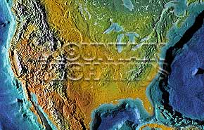
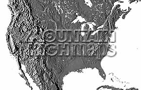
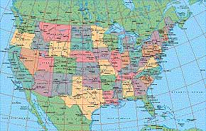
Top left: Elevation low-contrast relief rendering Top right: Vegetation high-contrast relief rendering Middle left: Grayscale land-only relief rendering Middle right: Political low-contrast relief rendering Lower right: Geo-political vector Illustrator EPS maps Illustrator USA vector EPS preview/detail map Inventory of maps and masks within each map portfolio
|
 Illustrator USA vector EPS preview/detail map Combined USA Vector & Relief preview/detail map |

| USA Map #204 - Buying Options |
||||||||
|
USA Vector only EPS map (bottom left map image) |
USA Relief/Vector Map (all maps on this page) |
America Continent Relief/Vector 16 Map Package |
Mountain High Maps Relief/Vector 78 Map Package | |||||
Any comments or problems with this
site? Please
let us know
- thank you!
© Digital Wisdom, Inc.